
(scroll down for English version)
Parque Nacional Abel Tasman
A las 8:00 am había que estar en el Centro de Kayaks, por lo que nos levantamos temprano, pagamos nuestro dólar por 6 minutos de agua caliente para bañarnos, desayunamos y salimos del Holiday Park.
Nos encontramos con la guía (una gordita simpática de nombre Jenna) y los de mas del grupo (en total 7 personas). Nos dio el plan para el día y nos dio la explicación del equipo que usaríamos. Como la Flaca y yo nos quedamos acampando una noche, nos dio la estufa, gasolina y la bolsa de dormir extra, y nos dio instrucciones de donde y a que hora recoger y dejar la mochila grande (para no cargar con el, pagamos para que un aqua taxi lo dejara y recogiera en la playa donde vamos acampar).
Nos subimos a un camioncito que nos llevo a la playa, donde un aquataxi nos estaba esperando. Como la marea estaba muy baja, nos subimos al aquataxi cuando todavía no estaba en el agua y un tractor jalo el remolque, donde estaba sentado el aquataxi, hasta donde el nivel del agua era suficiente para bajar y prender el motor.
En un recorrido de unos 35 minutos, a lo largo de la costa del parque nacional Abel Tasman, el aquataxi nos llevo hasta la Playa Onetahuti desde donde salimos en kayak hacia la Isla de Tonga y luego a la Playa de Medlans en la Bahía Bark.

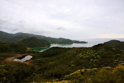
El parque nacional Abel Tasman esta localizado en el noroeste de la isla sur, en la costa de las Bahías de Tasmania y Golden. El nombre de parque viene del primer explorador europeo que vio Nueva Zelanda. No es un parque muy grande, ya que solo tiene una extensión de 225 kilómetros cuadrados, pero es famoso por la vegetación, sus playas, y sus paisajes.
Una vez en la Playa Onetahuti, Jenna nos dio algunas indicaciones para remar, para salirnos del kayak si se voltea y algunas otras cosas. Nos subimos (la Flaca y yo en un kayak) y empezamos nuestro camino hacia la Isla de Tonga.

El día estaba muy bonito; el clima era perfecto para estar en el mar. Hacia calor, pero no demasiado, con una brisa fresca ligera y no había una sola nube.
Tan pronto nos acercamos a la Isla de Tonga, Jenna nos señaló algunas focas y nos dijo que en un par de meses, mas entrada la primavera, esta isla estaría llena de focas cuidando a sus crías. También nos dijo que en algunas ocasiones, había pingüinos, no nos toco ver ninguno.
Rodeamos la isla y seguimos nuestro camino por la costa en dirección sur-este, para este entonces nuestro brazos empezaban a cansarse, por lo que la Flaca y yo queríamos que alguien le prendiera al motor del kayak.
Una hora y media mas tarde llegamos a la Playa Medlans, donde comimos y donde termino nuestro recorrido en kayak. De aquí en adelante empezaba nuestro recorrido a pie. Al terminar el almuerzo, nos despedimos de Jenna (quien siguió su camino de regreso en su kayak) y de los demás turistas del grupo (quienes iban hasta Marahau) y nos quedamos un rato disfrutando de la playa y el día.
Nuestro destino era la Bahía de Anchorage, donde estaba nuestra mochila y donde pasaríamos la noche. Empezamos nuestro camino, que seria recorrer una parte de la popular vereda conocida como Abel Tasman Coast Track (esta vereda completa se extiende por 54.4 km). Esta vereda siempre siguiendo el contorno de las montañas.

Las playas, la vegetación, las montañas y el mar hacían una combinación de paisajes que nos sorprendía en cada espacio claro de vegetación.


Al llegar a la Bahía Torrent, ya llevábamos un poco mas de dos horas de camino. Jenna nos había dicho que por la hora en la que mas o menos íbamos a llegar a este lugar, tendríamos que dar la vuelta a la bahía en lugar de caminar a través de ella, ya que la marea iba a estar muy alta para entonces. Pero antes de tomar el camino largo, bajamos hasta la playa para ver que tan alta estaba la marea y poder decidir. La marea no estaba tan alta así que decidimos cruzar.

Tuvimos que levantarnos un poco los shorts y la Flaca quitarse los zapatos, que después se volvió a poner porque caminar por las conchitas estaba muy doloroso. Además cruzamos tres entradas de agua y una zona de mucho lodo, donde unos pequeños cangrejos huían de nuestras lentas pisadas, para poder llegar hasta la otra orilla de la bahía Torrent. Desde aquí caminamos otros 15 minutos (en vez de hora y media) para llegar a la bahía Anchorage.


La Bahía Anchorage no es muy grande, pero por poco y es lago porque la abertura es pequeña. Nosotros llegamos por el norte y caminamos por la playa, admirando el paisaje, hasta un poco mas de la mitad para encontrar nuestra mochila y el lugar designado para acampar.

Encontramos un lugar para poner la casa de acampar, la pusimos rápidamente, y regresamos a la playa para ver el atardecer. Aunque había mucha gente en el campamento, no había mucha gente viendo el atardecer; de hecho hubo un momento en que la Flaca y yo nos quedamos solos hasta que llegaron un señor con su hijo, que venia en una balsa de un yate que estaba anclado en la bahía.

El cielo seguía estando despejado y de color azul claro. El sol se fue ocultando detrás de las montanas, el cielo fue obscureciendo, las estrellas poco a poco empezaron a brillar y empezó hacer frío.

Regresamos al campamento para preparar la cena; solo comeríamos pasta con un poco de salsa de tomate y olivas. El viento empezó a soplar y era muy frío, así que la Flaca decidió meterse a la casa de acampar mientras estaba la comida.
La estufa que habíamos rentado no era muy buena porque el agua tardo mas de una hora en calentarse. Con la poca paciencia de los dos y con el frío, puse a la pasta en el agua antes de tiempo y duro como otros 45 minutos en estar lista; casi nos la comemos cruda. Al final, con las prisas de meternos a la casa de acampar por el frío y con el hambre, nos la comimos directo de la olla; como dijo la Flaca parecíamos vagabundos.
Durante la noche hizo bastante frío y viento, pero dentro de la casa no se sentía mucho; solo se movía un poco por el viento. Aunque no caímos dormidos rápidamente por el clima exterior, en algún punto de la noche nos dormimos, y profundamente, porque no escuchamos el despertador y a las 8:30 am nos levantamos sorprendidos por la hora y a prisas porque la mochila tenia que estar lista en la playa a las 9:00 am.
Saltamos de las bolsas de dormir y mientras ella arreglaba lo de adentro, yo empecé a quitar la casa y guardar la estufa y demás. A las 9:05 am y corriendo deje la mochila en la playa. Todavía no llegaban por las demás. Es mas, cuando empezamos a caminar a las 10:15 am la mochila seguía ahí, hasta la Flaca tuvo chance de sacar otra sudadera.
El segundo día teníamos entre cuatro y cinco horas de caminata frente a nosotros. El clima no fue tan bueno, es mas hasta se sentía fresco, y en ocasiones entre la vegetación hasta frío era. Sin embargo, los paisajes seguían siendo sorprendentes.


El camino empezó con algunas subidas y la Flaca, aunque esta en la mejor forma de su vida, se quejo un poco y despacito subió todas. Pasamos por varias bahías, sin bajar hasta la playa, hasta que llegamos a la bahía de Coquille donde decidimos bajar y comer nuestro almuerzo.


Éramos los únicos en la playa. No hemos encontrado mucha gente en todo el recorrido, y en esta pequeña y hermosa playa éramos los únicos. Apenas empieza la temporada alta, así que en un par de meses va estar todo lleno.
Comimos y nos quedamos un rato acostados sobre la arena recargando la cabeza en un tronco; hasta una siesta me eche. En la hora y cacho que estuvimos ahí, solo un par de personas pasaron cerca de nosotros.

Seguimos nuestro camino y como a las 4:00 pm, llegamos de regreso a Marahau. Recogimos nuestra mochila y el Cheapo, y salimos con rumbo a Nelson. Nelson es una ciudad a una media hora de donde estábamos, aquí pasaríamos la noche.


Hicimos dos paradas antes, la primera en Motueka para entrar al Internet para mandar un correo electrónico a Sigurd y Nanna (la pareja de daneses que conocimos en Sydney) porque sabíamos que estaban cerca de esta zona y queríamos encontrarnos con ellos. Les avisamos que íbamos rumbo al Holiday Park de Nelson y que si podían, nos fueran a encontrar después de las 6:00 pm. La segunda parada en el supermercado para comprar comida.
Al llegar al Holiday Park de Nelson, estábamos buscando donde estacionarnos y justo nos encontramos a Sigurd y Nanna que acababan de llegar. También iban a pasar la noche ahí.
Preparamos de cenar e hicimos un tipo buffet familiar. Sigurd y Nanna nos compartieron sus hamburguesas y nosotros nuestro arroz con pollo y salsa agridulce. Nos platicamos nuestras ultimas cuatro semanas, desde que nos separamos en Sydney, en las que hemos sufrido de clima lluvioso y con viento, y nos dieron algunas recomendaciones de la isla sur y nosotros de la norte.

Platicamos hasta como la media noche y nos fuimos a dormir; ellos mañana cruzan a la isla norte y nosotros seguimos nuestro camino hacia el sur. Mañana nos despedimos de ellos y no sabemos cuando los veremos de nuevo. Esperamos poderlos visitar en Copenhagen cuando estemos en Europa.
Siempre es bueno encontrar caras conocidas durante el viaje, y en estos últimos días, tuvimos la suerte de ver a dos parejas que nos caen muy bien.
Abel Tasman National Park
We had to be at the Kayak Center at 8:00 am, so we got up early, paid a dollar for 6 minutes of hot water to shower, ate breakfast and left the Holiday Park.
We met our guide (a nice girl named Jenna) and the rest of the group (a total of 7 people). She gave us the plan for the day and explained the equipment that we’d use. Since la Flaca and I will camp overnight, she gave us a stove, gas and an extra sleeping bag, and she gave us instructions regarding where and when we’d pick up and leave our big backpack (in order not to have to carry it, we paid for an aqua taxi to leave it and pick it up at the beach where we were going to camp).
We boarded a small truck that took us to the beach, where an aqua taxi was waiting for us. Since the tide was very low, we got on the aqua taxi when it was not yet in the water and a tractor pulled the platform, where the aqua taxi was sitting, until the water was high enough to start the motor.
On a journey of about 35 minutes, along the coast of Abel Tasman National Park, the aqua taxi took us to Onetahuti Beach where we went out on a kayak toward Tonga Island and later Medlans Beach and Bark Bay.
Abel Tasman National Park is located in the northeast of the South Island, on the coast of Tasman and Golden Bay. The park was named after the first European explorer who saw New Zealand. It’s not a very large park, since it is only about 140 square miles, but it is famous for its vegetation, its beaches, and its landscapes.
Once at Onetahuti Beach, Jenna gave us some directions about how to row, what to do if the kayak turns over and a few other things. We got in (la Flaca and I in one kayak) and we began our journey toward Tonga Island.
The day was very pretty; the weather was perfect to be on the ocean. It was warm, but not too much, with a cool breeze and not a single cloud.
As soon as we got close to Tonga Island, Jenna showed us some seals and told us that in a few months, further into Spring, this island would be full of seals taking care of their babies. She also told us that on a few occasions, there are penguins, but we didn’t see any.
We circled the island and continued on our path along the coast toward the southeast; by now our arms were beginning to tire, so much so that la Flaca and I wanted someone to turn on a motor for the kayak.
An hour and half later, we arrived to Medlans Beach, where we ate and where our kayak journey came to an end. From here began our journey on foot. After lunch, we said goodbye to Jenna (who returned in kayak) and the rest of the tourists (who were headed toward Marahau) and we stayed for a while enjoying the beach and the day.
Our destination was Anchorage Bay, where our backpack was waiting for us and where we’d spend the night. We began our walk, which would be to follow a part of the popular trail known as Abel Tasman Coast Track (the complete trail extends for about 34 miles). This trail always follows the shape of the mountains.
The beaches, the vegetation, the mountains and the ocean created a combination of landscapes that surprised us with each open space between the vegetation.
Upon arriving to Torrent Bay, we had already been walking for a little more than two hours. Jenna had told us that at the time we would reach this place, we would need to walk around the bay rather than across it, since the tide would have come in by now. But before taking the long road, we went down to the beach to see how high the tide was in order to decide. The tide was not that high so we decided to cross.
We had to roll up our pants a bit and la Flaca had to remove her shoes, but after she put them back on because it hurt quite a lot to walk on the shells. We crossed three areas where the water had begun to come in and an area with a lot of mud, where some small crabs fled from our slow steps, in order to reach the other edge of Torrent Bay. From here we walked another 15 minutes (instead of an hour and a half) to reach Anchorage Bay.
Anchorage Bay is not very big; in fact it’s almost a lake because the opening or mouth of the bay, toward the ocean, is small. We arrived from the north and walked along the beach, admiring the scenery, until we reached what was about the middle to find our backpack and the area designated for camping.
We found a place to put our tent, we put it up quickly, and returned to the beach to watch the sunset. Although there were a lot of people in the campground, there were not a lot of people watching the sunset; actually, there was a moment when la Flaca and I were alone until a man arrived with his son, who had come on a boat from a yacht that was anchored in the bay.
The sky was still clear and a light blue color. The sun began to set behind the mountains, the sky began to darken, the stars began to shine little by little and it began to get cold.
We returned to the campsite to prepare dinner; we’d only eat pasta and a little bit of sauce with tomatoes and olives. The wind began to blow and it was very cold, so la Flaca decided to get inside the tent until the food was ready.
The stove that we had rented was not very good because the water took more than an hour to heat up. With little patience and with the cold, I put the pasta in the water before it was ready and it took another 45 minutes to be ready; we almost ate it raw. In the end, with the rush to get inside the tent due to the cold and with our hunger, we ate directly from the pot; as la Flaca said we looked as if we were homeless.
During the night it was pretty cold and windy, but you couldn’t feel much inside the tent; it just moved a bit from the wind. Although we didn’t fall asleep quickly due to the weather outside, at some point in the night we slept, and deeply, because we didn’t hear the alarm and at 8:30 am we got up surprised by the hour and in a hurry because the backpack had to be ready on the beach by 9:00 am.
We got out of the sleeping bags and while she packed up what was inside, I began to take the tent down and put away the stove and other things. At 9:05 am I ran to leave he backpack on the beach. They hadn’t come yet for the rest. What’s more, when we began to walk at 10:15 am, the backpack was still there, la Flaca was even able to take out another fleece.
The second day we had between four and five hours of walking in front of us. The weather was not as nice, it even felt cool, and on occasion, among the vegetation, it was cold. However, the landscapes continued to be surprising.
The trail began with some hills and la Flaca, although in the best shape of her life, complained a little and climbed them slowly. We passed by several bays, without going down to the beach, until we reached Coquille Bay where we decided to go down and have lunch.
We were the only ones on the beach. We hadn’t found many people along the way, and on this small and beautiful beach we were the only ones. The high season is just beginning, so in a few months it will be full of people.
We sat and stayed a while laying on the sand and resting our head on a tree trunk; I even took a nap. In the hour and a bit that we were there, only one other couple passed near us.
We continued on our hike and at about 4:00 pm, we arrived back in Marahau. We picked up our backpack and el Cheapo, and left toward Nelson. Nelson is a city a half an hour from where we were, where we’d spend the night.
We made two stops before, the first in Motueka to go online to send an email to Sigurd and Nanna (the Danish couple we met in Sydney) because we knew they were nearby this area and we wanted to meet up with them. We let them know we were headed to the Holiday Park in Nelson and if they could, to meet us there after 6:00 pm. The second stop was at the supermarket to buy food.
Upon arrival to the Holiday Park of Nelson we were looking for a place to park and found Sigurd and Nanna who had just arrived. They were also going to spend the night there.
We made dinner and made a family buffet. Sigurd and Nanna shared their hamburgers and we shared our sweet and sour chicken with rice. We talked about our last four weeks, since we had left each other in Sydney, about how we’d suffered from the rainy and windy weather, and they gave us some recommendations about the South Island while we gave them recommendations about the North Island.
We talked until about midnight and then went to bed; tomorrow they cross to the North Island and we continue on our way south. We would say goodbye to them tomorrow and don’t know when we’ll see them again. We hope to visit them in Copenhagen when we’re in Europe.
It’s always good to see familiar faces during the trip, and in the last few days, we’ve been lucky to see two couples that we get along with great.
No comments:
Post a Comment