
(scroll down for English version)
Punakaiki y los Glaciares Franz Josef y Fox
Regaderaso, pan francés de desayuno (con el cual llene de humo la cocina del Holiday Park a tal grado que tuvimos que abrir la ventanas aunque afuera estaba haciendo frío), y tomamos la carretera hacia el sur. Íbamos rumbo a los glaciares Franz Josef y Fox con una parada en Punakaiki.
Este recorrido, a lo largo de la costa del Mar de Tasmania, es considerado por Lonely Planet (compañía editora de libros de viaje) como uno de los 10 mejores viajes por carretera del mundo. Nosotros esperábamos que la lluvia no fuera arruinar del todo el paisaje.

Llegamos a Punakaiki, y aunque seguía lloviendo y nublado, el recorrido había estado bonito. El mar revuelto, chocando contra las piedras y los arrecifes, y las nubes le habían dado un toque dramático, como dice la Flaca.

Punakaiki, en la orilla del mar, es famoso por sus formaciones rocosas que parecen torres de hotcakes (de hecho ingles se le conoce como las “Pancake Rocks”) y bufadoras (hoyos por donde el agua sale hacia arriba empujada por la corriente).
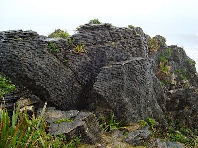

Cogimos nuestros impermeables y nos bajamos del Cheapo. Un camino de pavimento rodeado por vegetación nos fue acercando a la orilla del acantilado donde las torres de hotcakes, día tras día, son erosionadas por el agua.

El recorrido nos llevo cerca de dos bufadoras y entre las torres de hotcakes, estas ultimas altas y mas bajitas, anchas y angostas. Es como un lugar diferente. El paisaje es bonito, aunque a nosotros nos toco muy nublado, pero lo peculiar de las formaciones rocosas lo hacen un lugar único.
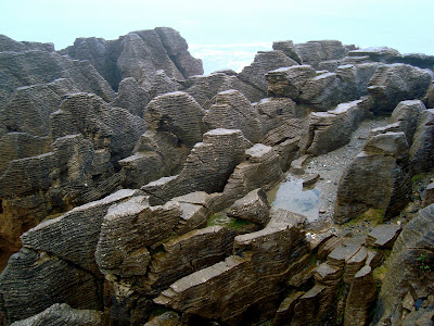

Después de hacer el recorrido completo tratando de tomar fotos y cuidando que la cámara no se moje mucho, yo decidí dar otra vuelta y la Flaca prefirió regresar al Cheapo. Tuvo suerte porque cuando iba como a la mitad de mi segunda vuelta, empezó a llover mas fuerte y regrese con los pantalones bastante mojados al campervan.
Seguimos nuestro camino hacia los glaciares. El paisaje cambio. La lluvia y las nubes seguían acompañándonos, pero dejamos el mar y aparecieron las montañas nevadas.

Llegamos al poblado de Fox Glacier, donde esta el glaciar del mismo nombre y donde esta el Holiday Park donde pasaríamos la noche. La lluvia había quedado atrás y entre las nubes pudimos ver por un rato el Monte Cook, el mas alto de Nueva Zelanda.

Después de cenar con un poco de vino y unas galletitas Tim Tam de postre (estas galletas son las mejores que hay; si algunas vez están en Australia o Nueva Zelanda no dejen de comerlas, especialmente las de chocolate amargo), nos fuimos a dormir.
Por la mañana, desconectamos el Cheapo y nos fuimos hacia el poblado de Franz Josef; aquí tomamos el tour hacia el glaciar del mismo nombre. El día, otra vez, estaba nublado y amenazaba lluvia.
Llegamos a la oficina de los guías del glaciar (www.franzjosefglacier.com), pagamos el tour, nos dieron varias tarjetitas de colores unidas por una argolla, y las instrucciones empezaron. La tarjetita azul era para los pantalones y la chamarra, la amarilla para las botas y calcetines, la verde para los guantes y el gorro, y la roja para los crampones.
Con toda la ropa puesta y arriba de un camión, iniciamos el tour. El camión nos llevo hasta la entrada del parque donde esta el glaciar y desde ahí caminamos, primero por un camino de pavimento, pero luego nos metimos por una vereda hasta que llegamos a un río seco, desde donde pudimos ver el glaciar por primera vez.
En este punto, nos dividieron en cuatro grupos y así caminamos por una hora hasta llegar a la orilla del glaciar. Para la mitad del camino, la lluvia que había sido muy suave tomo fuerza. La guía nos comento que en esta zona llueve en promedio 300 días del año, entonces entendí el porque de toda la ropa que te dan.

Antes de entrar a la zona de puro hielo, nos indicaron que era tiempo de ponernos los crampones y así lo hicimos. En fila india fuimos entrando poco a poco en le hielo y subiendo el glaciar.

La Flaca, que según ella, andaba un poco nerviosa y con miedo, no podía quitar la sonrisa de emoción de su cara.
JP – y esa cara???
La Flaca – pues que, esta padre…
JP – y donde quedo el miedo, el frío, porque esta lloviendo y estamos caminando en hielo; no que muy friolenta?
La Flaca – que? (su sonrisa se extendió todavía mas)
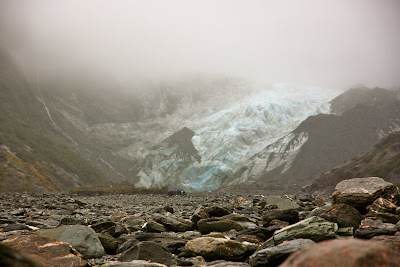
El glaciar Franz Josef esta localizado en la costa oeste de Nueva Zelanda dentro del parque nacional Westland. El glaciar tienen una longitud de 12 kilómetros.

El nombre (del glaciar) en ingles lo lleva por el emperador austriaco, Franz Josef I. El nombre en Maori, Ka Roimata o Hinehukatere (las lagrimas de Hinehukatere), se debe a la leyenda que cuenta que Hinehukatere era una experimentada alpinista y convenció a su novio, Wawe, para que escalara con ella. Una avalancha sepulto a Wawe y desde la cumbre, Hinehukatere, con el corazón destrozado, lloro y lloro. Sus lagrimas fluyeron hasta abajo y se congelaron formando el glaciar.
Seguimos subiendo. Primero por encima del hielo y luego por entre el hielo en grietas que se han ido formando con el paso de los años. La Flaca seguía feliz. Después me confeso que las siete prendas que traía habían ayudado a disfrutar mas la caminata sobre el hielo.


Después de un hora, mas o menos, iniciamos el descenso. En una de las grietas, uno de los señores que venia con nosotros perdió el equilibrio y se cayo. Pensamos que había sido grave porque se vio muy aparatoso, pero tuvo suerte y no le paso nada.
Al llegar a la tierra, nos quitamos los crampones e iniciamos nuestra caminata hasta la entrada del parque, donde nos estaba esperando el camión para llevarnos de regreso a las oficinas de los guías para entregar el equipo, recoger al Cheapo, e irnos al Holiday Park. Tratamos de ir a comer algo a un lugar que nos habían recomendado, pero estaba totalmente fuera de nuestro presupuesto, así que nos conformamos con picadillo con arroz.
Al día siguiente, nos levantamos y el día estaba soleado y no había muchas nubes, pero después de investigar el pronostico del clima nos dijeron que pronto se iba a nublar. Eran buenas noticias para poder ver el reflejo del Monte Cook en el agua del lago Matheson.
Un duchazo rápido, tan rápido que puede ser catalogado como baño vaquero, un desayuno a prisas y casi olvidando desconectar el Cheapo, salimos del Holiday Park con dirección del lago Matheson. Solo estaba a unos cuantos kilómetros de distancia, pero con la velocidad con la que cambia el clima aquí teníamos que apurarnos.

Llegamos al estacionamiento y las nubes ya estaban acercándose rápidamente. Nos bajamos del Cheapo y caminamos por unos 30 minutos hasta encontrar el mirador desde donde el paisaje nos dejo sin aliento. El reflejo del las montañas sobre el lago es un sueno. Las fotos pueden describir mejor lo que vimos.


Seguimos por la vereda, la cual estaba rodeada de vegetación verde, muy verde. Aquí llueve tanto que además de las hojas verdes de los árboles, el pasto es verde brillante y el musgo también. La vereda nos llevo todo alrededor del lago hasta el regresar al estacionamiento.

Ya con mas tranquilidad, salimos con rumbo al glaciar Fox. Este glaciar tiene una longitud de 13 kilómetros. Recibió el nombre en ingles después de la visita que hizo el Primer Ministro Neocelandés al lugar en 1872. El nombre en Maori es Te Moeka o Tuawe (lugar de descanso final); este proviene de la leyenda que cuenta que el ancestro Tuawe callo en el área mientras exploraba y la cama del glaciar se fue su lugar de descanso final (moeka).
El área donde están los glaciares Fox y Franz Josef, lleva por nombre Te Wahipounamu y forma parte de los sitios designados como patrimonios de la humanidad.
Nos estacionamos y caminamos unos 45 minutos por la cama del río, casi seco, hasta llegar al glaciar. Esta vez no caminamos sobre el hielo; solo lo vimos desde algunos metros de distancia.


Regresamos al Cheapo y tomamos el camino hacia Queenstown. El recorrido fue muy bonito lo que nos ayudo a empezar a comprender lo que mucha gente nos había comentado, la isla sur es mas bella que la norte.
Pasamos por caminos rodeados de vegetación muy verde, sobresaliendo los helechos, que es la planta oficial y que representa a Nueva Zelanda (espero no se vayan a marear con el video http://www.youtube.com/watch?v=kr5m27TV__U). En otros tramos de la carretera, las montañas se hicieron presentes, también con sus superficies muy verdes (espero no se vayan a marear con el video http://www.youtube.com/watch?v=3HgK2IiYo2I). Para aprovechar el paisaje, decidimos parar en la a comer nuestro almuerzo.
Antes de llegar a Queenstown, la carretera nos llevo cerca de la costa y aunque seguía nublado, el escenario natural seguía sorprendiéndonos. Después, otra vez hacia tierra adentro. El cielo empezó a despejarse un poco y encontramos los lagos Wanaka y Hawea, que en combinación con las montañas nevadas, hacían un paisaje increíble. Nos hemos dado cuenta que mencionamos mucho la palabra increíble, pero es que los paisajes en este país realmente son de una belleza difícil de describir.


Llegamos a Queenstown como a las 4:30 pm. Encontramos el Holiday Park, que mas que nada era un estacionamiento donde había unos 200 campervans. Nos asignaron un lugar, el cual estaba lleno de lodo porque había llovido los últimos días, nos conectamos y salimos a comprar algunos víveres para preparar de cenar. Al ir regresando de la tienda, empezó a llover otra vez. Mañana empezaremos nuestra visita esta ciudad, que además de ser un lugar reconocido para esquiar en nieve, dicen es la capital de los deportes de aventura de Nueva Zelanda.
Punakaiki and the Franz Josef and Fox Glaciers
A quick shower, French toast for breakfast (with which I filled the Holiday Park kitchen with so much smoke that we had to open the windows even though it was cold), and we were off on the road toward the South. We were headed toward the Franz Josef and Fox glaciers with a stop in Punakaiki.
This journey, along the coast of the Tasman Sea, is considered by Lonely Planet (travel book company) as one of the 10 best road trips in the world. We were hoping the rain would not ruin all of the scenery.
We arrived to Punakaiki, and although it was still raining and cloudy, the journey had been pretty. The thrashing sea, crashing against the rocks and reef, and the clouds had given it a dramatic touch, as la Flaca says.
Punakaiki, on the edge of the sea, is famous for its rock formations that look like towers of pancakes (actually they are known as the Pancake Rocks) and blowholes (holes from where water shoots up pushed from the current).
We grabbed our raincoats and got out of el Cheapo. A paved road surrounded by vegetation brought us closer to the edge of the cliff where the pancake rocks, day after day, are eroded by the water.
The pathway took us near two blowholes and between the pancake rocks, some tall and some shorter, wide and narrow. It’s like another world. The scenery is beautiful, even though it was very cloudy when we were there, but the peculiarity of the rock formations make this a unique place.
After making a complete walk around the path trying to take photos and ensuring the camera wouldn’t get very wet, I decided to make another round and la Flaca preferred to return to el Cheapo. She was lucky because when I was about halfway around the second time, it began to rain harder and I returned to the campervan with pretty wet pants.
We continued on our journey toward the glaciers. The landscape changed. The rain and the clouds continued on with us, but we left the sea and the snowy mountains appeared.
We arrived to the town of Fox Glacier, where the glacier by the same name is located as well as the Holiday Park where we’ll spend the night. We had left the rain behind and between the clouds we could see Mount Cook for a while, the tallest mountain in New Zealand.
After having dinner with a little bit of wine and some Tim Tam cookies for dessert (these are the best cookies; if you are ever in Australia or New Zealand don’t forget to eat them, especially the dark chocolate ones), we went to bed.
In the morning, we disconnected el Cheapo and went toward the town of Franz Josef; here is where we take the tour to the glacier by the same name. The day, again, was cloudy and threatened rain.
We arrived to the office of the glacier guides (www.franzjosefglacier.com), we paid for the trip, they gave us various different colored cards attached by a ring, and the instructions began. The blue card was for the pants and jacket, the yellow for the boots and socks, the green for the gloves and hat, and the red for the crampons.
With all the clothing on and boarded on the bus, we began our trip. The bus took us to the entrance to the park where the glacier is and from there we walked, first on a paved road, but later we went on a dirt path until we reached a dry riverbed, from where we could see the glacier for the first time.
At this point, they divided us into four groups and we walked for an hour until we reached the edge of the glacier. By the time we were halfway, the rain that had been very light began to come down harder. The guide told us that it rains on average 300 days out of the year in this area, so I understood why they give you so much clothing.
Before entering the area of pure ice, they told us it was time to put on the crampons and so we did. In single file we began entering onto the ice little by little and climbing up the glacier.
La Flaca, who according to her, was a little nervous and scared, couldn’t take the smile off of her face.
JP – and that face???
La Flaca – well, it’s cool…
JP – and where did the fear go, and cold, because it’s raining and we’re walking on ice, aren’t you always very cold?
La Flaca – what? (her smile got even bigger)
The Franz Josef glacier is located on the west coast of New Zealand in the Westland National Park. The glacier is about 7.5 miles long.
The name (of the glacier) in English is from the Austrian emperor, Franz Josef I. The name in Maori, Ka Roimata o Hinehukatere (the tears of Hinehukatere), comes from the legend that says Hinehukatere was an experienced alpinist and she convinced her boyfriend, Wawe, to climb with her. An avalanche buried Wawe and from the peak, Hinehukatere, with her heart destroyed, cried and cried. Her tears flowed to the bottom and froze forming the glacier.
We continued climbing, first on top of the ice and then between the ice in crevices that have formed through the years. La Flaca was still happy. She later confessed that the seven layers that she was wearing had helped her enjoy the climb over the ice.
After about an hour, we began our descent. In one of the crevices, one of the men that came with us lost his balance and fell. We thought that it was a hard fall because he looked pretty frightened, but he was lucky and he was fine.
Upon arriving back to the dirt, we took off our crampons and began our walk back to the entrance of the park, where the bus was waiting to take us back to the offices to return our equipment, pick up el Cheapo, and go to the Holiday Park. We tried to go to eat at a restaurant recommended to us by a friend, but it was completely out of our budget, so we settled for picadillo (minced beef with vegetables) with rice.
The next day, we got up and it was sunny and there weren’t many clouds, but after investigating the weather forecast they told us that it was going to cloud over. It was good news to be able to see the reflection of Mount Cook in the water of Lake Matheson.
A quick shower, a hurried breakfast and almost forgetting to disconnect el Cheapo, we left the Holiday Park toward Lake Matheson. It was only about 2.5 miles away, but with the speed at which the weather changes here we had to hurry.
We arrived to the parking lot and the clouds were already beginning to move in quickly. We got out of el Cheapo and walked for about 30 minutes until we found the lookout point from where the landscape left us breathless. The reflection of the mountains on the lake was a dream. The photos can better explain what we saw.
We continued along the path, which was surrounded by green vegetation, very green. It rains so much here that in addition to the green leaves of the trees, the grass is a bright green and the moss as well. The path took us around the lake until we returned to the parking lot.
Now with a more leisurely pace, we left toward Fox Glacier. This glacier is about 8 miles long. It got its name in English after the visit of the first New Zealand Prime Minister in 1872. The Maori name is Te Moeka o Tuawe (final resting place); this comes from the legend that says the ancestor of Tuawe fell in the area while he was exploring and the bed of the glacier became his final resting place (moeka).
The area where Fox and Franz Josef glaciers are is named Te Wahipounamu and forms part of a region that is designated as a World Heritage Site.
We parked and walked for about 45 minutes on the riverbed, which was almost dry, until we reached the glacier. We didn’t climb on the ice this time; we just saw it from a few meters away.
We returned to el Cheapo and went on our way to Queenstown. The journey was very pretty and helped us understand what many people have told us, that the South Island is more beautiful than the North.
We passed through roads surrounded by very green vegetation, mostly ferns, which is the official plant and represents New Zealand (I hope this video doesn’t give you motion sickness http://www.youtube.com/watch?v=kr5m27TV__U). In other parts of the road, the mountains became apparent, also with a very green surface (again, I hope this video doesn’t give you motion sickness http://www.youtube.com/watch?v=3HgK2IiYo2I). To take advantage of the landscape, we decided to stop and eat our lunch.
Before arriving to Queenstown, the road took us near the coast and although it continued to be cloudy, the natural scenery continued to surprise us. Later, the road took us inland. The sky began to clear a little and we came across Lakes Wanaka and Hawea, which in combination with the snow-covered mountains, created an incredible landscape. We have realized that we mention the world incredible a lot, but it is because the landscapes in this country are really of a beauty that is difficult to describe.
We arrived to Queenstown at around 4:30 pm. We found the Holiday Park, which is not much more than a parking lot where there were about 200 campervans. They assigned us a space, which was full of mud due to the fact that it had rained the last few days, we connected, and went out to buy some food for dinner. As we were returning from the store, it began to rain again. Tomorrow we were looking forward to our visit to the city, which is not only a place known for skiing, they say it is the capital of extreme sports in New Zealand.
No comments:
Post a Comment